Day 2, Stop 8
Panorama Point
GPS Location:
38o 18.428' N
111o 17.751' W
Ages:
Triassic
Rock Units:
Chinle Formation
Moenkopi Formation
Features Present:
Panorama Point is a great location to view the diverse geology of Capitol Reef National Park (Figure 1). The formations of the Jurassic Glen Canyon Group are readily apparent. The red Wingate Sandstone is overlain by the distinctly bedded Kayenta Formation ,which is then overlain by the white Navajo Sandstone. The Waterpocket Fold monocline has tilted these formations 10° to the east in this area (Mathis, 2000). A monocline is a geologic feature where the layers of sediment have been altered and compressed and resemble a stretched out “s” on its side. The monocline in Capitol Reed National Park is 100 miles long (Morris, 2003).
This area of Capitol Reef National Park boasts about having the cleanest, clearest air in America. On a clear, sunny day, one can see the Henry Mountains in the distance. The tallest peak in the Henry Mountains is Mount Ellen at an elevation of 11,615 feet (Mathis, 2000). The Henry Mountains were formed 31.2-23.3 Ma (million years ago). Named by John Wesley Powell, this was the last mountain range to be mapped in the lower 48 states of America (Mathis, 2000).
Near the parking lot at Panorama Point is a large outcrop that displays Triassic Moenkopi Formation (tidal) overlain by the greenish-grey Shinarump member (fluvial) of the Chinle Formation. In Figure 2, one can see the distinctive formations as well as the noticeable sequence boundaries. At the bottom of the outcrop, the red, layered-cake looking rock is the Moenkopi Formation. Especially noticeable on the right side of this figure on top of the Moenkopi formation are the two sequence boundaries (S1 at the bottom and S2 at the top; R. Dubiel 2010 pers. comm.) of the Shinarump (the white to tan colored rock capping the red Moenkopi). Above that is the white to green colored Chinle eroding into soft triangle-shaped mounds followed by more white/tan rock that represents a fluvial part of the Chinle Formation.
Other:
Goosenecks Overlook: Optional Foot Trail
From the parking lot of Panorama Point, the 0.1mile foot trail leading you to the Goosenecks Overlook is an option for people who want to see the oldest rock formations exposed in Capitol Reef National Park (Mathis, 2000). The Goosenecks Overlook looks down into the 800 feet deep Sulphur Creek canyon. The creek has eroded the rocks in a wandering way that produced a shape that resembles that of a goose’s neck, hence the name Goosenecks Overlook (Mathis, 2000). The canyon floor exposes the Permian age rocks (250 to 290 million year old) of the Cutler Group (Morris, 2003). The most basal unit at the bottom of this canyon is the White Rim Sandstone. The White Rim Sandstone is white due to the bleaching of hydrocarbons. The White Rim Sandstone environment was eolian, a coastal dune complex subjected to periodic flooding by marine waters (Kamola and Chan, 1988). Interfingering with the White Rim Sandstone is the overlying Kaibab Limestone. The Kaibab Limestone ranges from gray, buff, brown, to yellow/brown in color (Condon, 1997). It is an impure cherty limestone and dolomite, and represents deposition in a shallow marine shelf during the maximum eastward transgression of the Kaibab Sea (Condon, 1997). On top of the Kaibab is the canyon rim forming Moenkopi Formation (red).
Depositional Environment:
Chinle Formation - Fluvial and floodplains
Moenkopi Formation - Tidal
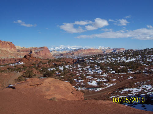
Figure 1: View from Panorama Point.
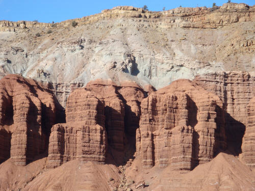
Figure 2: The Moenkopi formation overlain by the Chinle Formation.