Day 2, Stop 5
Hickman Bridge Hike
GPS Location:
Start of hike: End of hike:
38o 17.314' N 38o 17.481' N
111o 13.664' W 111o 14.062' W
Ages:
Early Jurassic
Rock Units:
Navajo Sandstone
Kayenta Formation
Features Present:
The Hickman Bridge hike is a 2 mile round trip hike to a natural bridge in the Kayenta Formation that includes several good outcrops along the way. In the distance large-scale eolian features in the Navajo Sandstone are evident.
In particular, the Hickman Bridge hike, like the Grand Wash hike, is a very good place to view eolian cross bedding even though the hike is entirely within the Kayenta Formation. Large-scale features can be seen in the Navajo formation at a distance, while other depositional features are close in the fluvial and eolian portions of the Kayenta.
Besides the Mesozoic geological features, there are a good variety of modern geologic features to see. Cenozoic black andesite and basaltic andesite boulders occur in the wash that have been eroded and transported from nearby Boulder and Thousand Lake Mountains. A developing field, known as in-situ terrestrial cosmogenic nuclide (TCN) radioactive dating, allows scientists to calculate an age of how long these boulders were exposed to the surface (like a “suntan”) and therefore gives us an idea of how long they have been sitting exposed in the park (Waitt 1998). TCNs are formed by bombardment of cosmic rays from the sun and other stars. Much the same as carbon-14 is produced in the atmosphere from the interaction of cosmic rays and nitrogen-14, isotopes of helium, beryllium, carbon and aluminum, among others, are produced in rocks due to the interaction of cosmic rays and the minerals and atoms in the rock. Since cosmic rays are the only source for most of these isotopes it is possible to determine an age on the sample based on how much of the isotope is present. Further, since cosmic rays cannot penetrate very far into the Earth, these cosmogenic nuclides are only produced within the top foot or so of the Earth’s surface. This means that the age that is determined by measuring the isotopes indicates how long the rock has been exposed at the earth’s surface (e.g., Fig. 1 boulders).
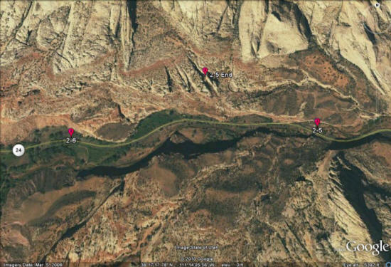
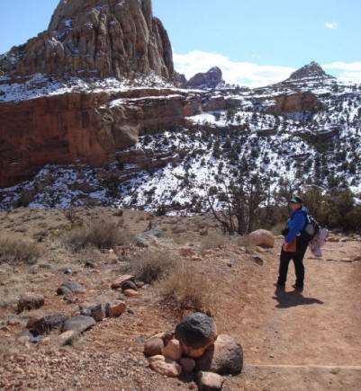
Figure 1:Black, volcanic (andesite) boulders derived from Boulder Mountain and Thousand Lake Mountain are part of the Pleistocene river terraces that cut into the Navajo Sandstone. The lava flows are between 30 Ma and 6 Ma old, but the boulders themselves are recent additions to the park. Absolute age dating using in-situ terrestrial cosmogenic radionuclides (TCN) of the boulders shows that they were exposed and eroded from the volcanic cliffs during the last Ice Age.
The angularity of the boulders indicates these were not transported by streams, and recent work shows that the glaciers in the area were fairly small, so neither rivers nor glaciers are considered to be the transportation agents for these boulders. Instead, increased rainfall during the Ice Age likely led to debris flows and wet landslides that flowed down from the high mountain plateaus into the lower river valleys. Since the boulders were deposited in the valleys the rivers have continued to erode downwards leaving the boulders perch on what are called strath terraces, the former river overbank areas.
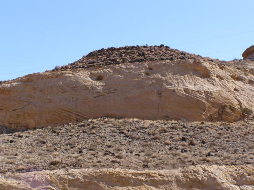
Figure 2: Although the Kayenta Formation is primarily fluvial and flood plain facies, some eolian deposits (this image) in the upper parts of the formation (Billingsley et al, 1987). General information on grain flow and wind ripple strata is in the Navajo Sandstone webpage.
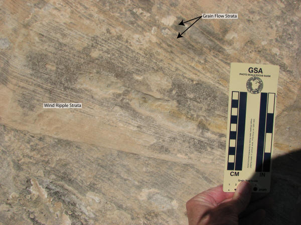
Figures 3-4: Internal wind ripple strata and the grain flow strata are distinguishable in the eolian crossbed sets. The wind ripple strata are the thin, parallel, “pin-stripe” laminations, and the grain flow strata are the thicker deposits that pinch out downdip. On close inspection with a hand lens the wind ripple laminae are inversely graded, i.e. the coarser sand grains are at the top of the laminae.
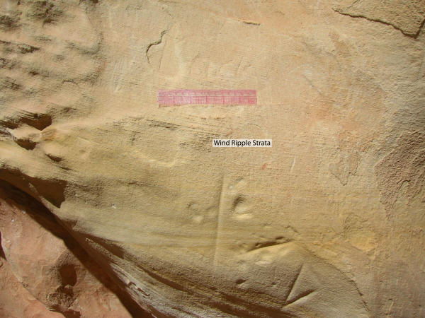
Figures 3-4: Internal wind ripple strata and the grain flow strata are distinguishable in the eolian crossbed sets. The wind ripple strata are the thin, parallel, “pin-stripe” laminations, and the grain flow strata are the thicker deposits that pinch out downdip. On close inspection with a hand lens the wind ripple laminae are inversely graded, i.e. the coarser sand grains are at the top of the laminae.
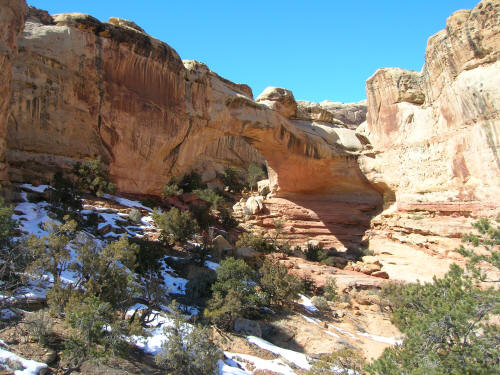
Figure 5: Hickman Bridge is a natural bridge in a white eolian unit within the upper Kayenta Formation. It is similar in appearance to, but not the same as the Navajo Sandstone. A natural bridge is similar in appearance to a natural arch, like those at Arches National Park, but is formed instead by different processes.
Hickman Bridge formed when water managed to weather a small opening into the rock dividing the two drainages at the bridge at a layer of mudstone. As more water flowed through the opening it continued to grow to its modern size, with the captured stream flowing underneath. By comparison, an arch is not created by flowing water, but is formed by freeze-thaw cycles of water in the rock slowly breaking the rock down. Though the resulting features may look similar, a bridge is likely to have a relatively flat top connecting two sides of a canyon with a stream underneath, whereas an arch is more likely to be free standing on a relatively flat surface and will not be associated with a stream (Mathis, 2000).
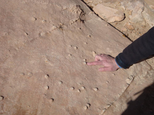
Figure 6: Concretions. Continuing up Hickman Bridge Trail, which is within the Kayenta Formation (Jurassic in age) one may encounter cemented mineral masses called concretions. These resemble spheres, but are composed of cemented sand from later fluids that moved through the porous sandstone. These concretions have calcite cement, as tested with the HCL acid which makes them fizz. Some concretions are aligned with the fractures in the rock where there would be preferential fluid flow. Some of the concretions were truncated against from a joint/fracture.
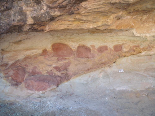
Figure 7: Debris Flow. Just before you reach Hickman Natural Bridge you pass by a debris flow. A debris flow is a moving mass composed of rock fragments, soil, and mud, where the majority of the particles are larger than sand size (Bates et al., 1984). The clasts are a mix of chaotic sizes. The unsorted flow becomes a slurry (a mix of water and fine grains) where the large boulders “float” to the top because the finer (smaller) particles float to the bottom. Scale bar is 10 cm long.