Day 2, Stop 1
San Rafael Group Overlook
Location:
East Park Boundary/San Rafael Group overlook, Highway 24 rest stop on north side of road.
GPS Location:
38o 17.042' N
111o 07.719' W
Ages:
Late Jurassic
Rock Units:
Summerville Formation
Curtis Formation
Entrada Sandstone
Carmel Formation
Features Present:
Rock layers to the north are Upper Jurassic, San Rafael Group including the Carmel Formation, Entrada Sandstone, Curtis Formation, and Summerville Formation (Figure 1). The basal red sandstones and siltstones of the Entrada Sandstone are topped by the Jurassic-3 (J3) unconformity and the greenish-gray, fine-grained Curtis sandstones. Sedimentary structures within the Curtis Formation transition up section from hummocky cross stratification to trough cross stratification (Wilcox, 2007). The Curtis Formation is relatively thin here (~ 24 m) and grades upward into redish brown silty mudstones of the Summerville Formation. Top of Curtis is often marked by a color change from greenish gray to the Summerville chocolate red. The Summerville is ~ 60 m thick here and consists of intercalated fine-grained sandstone, mudstone, and gypsum. The Summerville upper contact is the Jurassic-5 (J5) unconformity, overlain by lowermost beds of the Morrison Formation which forms the caprock.
Depositional Environment:
Marginal marine
The red beds of the Entrada Sandstone are underlain by Carmel Formation which typically shows soft sediment deformation (Figure 2). The Entrada Sandstone in this area was deposited in shallow water, probably in a tidal flat environment, whereas further east the Entrada transitions into an eolian environment. The Jurassic marine incursion over the Carmel deposits, transgressed generally from north to south and is characterized by basal medium to coarse sandstone that fines upward to calcareous green gray mudstone which represents the time of maximum flooding during the Curtis-Summerville cycle. Above the green gray marine mudstones, upward coarsening cycles are representative of a shoaling sea. Tidal sedimentary structures are present in the middle Curtis Formation to the north (See Stop 4 – 1 along I-70, Kreisa & Moiola 1986). Generally, more terrestrial facies occur to the south and open-marine conditions are documented to the north (Figure 3; Wilcox 2007). The upper 10 meters of Curtis and overlying Summerville Formation redbeds are intertidal mixed mud, sand flat, and tidal channel facies (Kreisa & Moiola, 1986).
Interpretation:
The Late Jurassic epicontinental seaway inundated the Entrada terrestrial deposits as recorded in the J3 unconformity marking the Curtis-Summerville Formations transgressive-regressive cycle. The basal Curtis contact may show erosional scours and lenticular fill along the J3 unconformity. In a sequence stratigraphic context, the Curtis-Summerville Formations are interpreted to represent one unconformably bound, transgressive-regressive (T-R) sequence associated with the Jurassic Interior seaway. Regionally, the Curtis Formation lithofacies thin to the south and thicken toward the Jurassic seaway in the north. Lower Curtis Formation green-gray mudstones (Figure 1) are interpreted as offshore marine (below fair-weather wavebase). Middle Curtis Formation ripple-cross laminations and flaser bedding are interpreted as tidally influenced lower shoreface and estuarine-like conditions. Upper Curtis Formation horizontal laminations are interpreted as subtidal to intertidal (Wilcox, 2007). As the Curtis-Summerville shoreline migrated seaward, the Summerville Formation reddish-brown silty mudstones are interbedded with evaporites, and is interpreted as a tidal flat, sabkha environment (Figure 3).
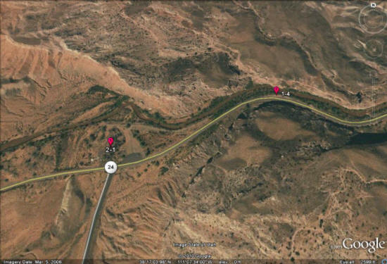
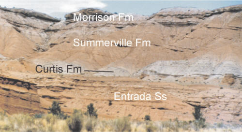
Figure 1: The uppermost units of the San Rafael Group (from bottom to top, Entrada Sandstone, Curtis Formation, and Summerville Formation) capped by the basal conglomerate of the Tidwell Member of the Morrison Formation (Mathis, 2000).
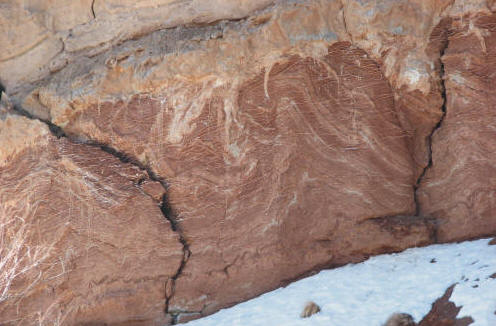
Figure 2: Soft sediment deformation in the Carmel Formation (scale: outcrop covers several meters).
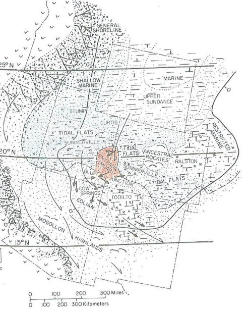
Figure 3: Middle-Late Jurassic paleogeography (Kocurek & Dott, 1983).